Thursday, December 26, 2019, Puerto Quetzal, Guatemala

Guatemala, officially the Republic of Guatemala, is a country in Central America bordered by Mexico to the north and west, Belize and the Caribbean to the northeast, Honduras to the east, El Salvador to the southeast and the Pacific Ocean to the south. With an estimated population of around 17.2 million, it is the most populated country in Central America. Guatemala is a representative democracy; its capital and largest city is Nueva Guatemala de la Asunción, also known as Guatemala City.
The territory of modern Guatemala once formed the core of the Maya civilization, which extended across Mesoamerica. Most of the country was conquered by the Spanish in the 16th century, becoming part of the viceroyalty of New Spain. Guatemala attained independence in 1821 as part of the Federal Republic of Central America, which dissolved by 1841.
From the mid to late 19th century, Guatemala experienced chronic instability and civil strife. Beginning in the early 20th century, it was ruled by a series of dictators backed by the United Fruit Company and the United States government. In 1944, authoritarian leader Jorge Ubico was overthrown by a pro-democratic military coup, initiating a decade-long revolution that led to sweeping social and economic reforms. A U.S.-backed military coup in 1954 ended the revolution and installed a dictatorship.
From 1960 to 1996, Guatemala endured a bloody civil war fought between the US-backed government and leftist rebels, including genocidal massacres of the Maya population perpetrated by the military. Since a United Nations-negotiated peace accord, Guatemala has witnessed both economic growth and successful democratic elections, though it continues to struggle with high rates of poverty, crime, drug trade, and instability. As of 2014, Guatemala ranks 31st of 33 Latin American and Caribbean countries in terms of the Human Development Index. Guatemala's abundance of biologically significant and unique ecosystems includes many endemic species and contributes to Mesoamerica's designation as a biodiversity hotspot.
Guatemala's population of ~17 million is 60% Mayans, 30% Mestizos, 10% Indigenous, and 3% Europeans. Primary sources in income are: Tourism, construction, and new or improved homes. Three of 37 volcanoes are active; the Atitlan Volcano is 11,500 feet high and last erupted 1832 and the Toliman Volcano is 10,000 feet high. Agricultural exports, in order 1 to 4, are: Sugar cane, caramel, bananas, and coffee.
PUERTO QUETZAL, GUATEMALA
Puerto Quetzal is Guatemala's largest Pacific Ocean port. It is important for both cargo traffic and as a stop-off point for cruise liners. It is located in Escuintla department, alongside the city of Puerto San José, which it superseded as a port in importance to the country's maritime traffic during the 20th century.


Local Life, Beautiful Landscapes & Markets
We enjoyed the beautiful Lake Atitlan in the Western Highlands of Guatemala and a scenic boat cruise. Famous for its natural beauty, we marveled at the stunning landscapes in the crater of an extinct volcano. The picture-postcard lake is ringed by small towns and charming villages and we enjoyed a stop along the way and meet the friendly villagers. We saw the traditional, brightly colored dresses worn by Mayan women, and learn more about their culture. As our guide explained the importance of agriculture and traditional handicrafts to the lake communities, we explored market stalls and mingled with locals as we admired the range of hand-woven tapestries, paintings, and ceramics. We saw a twelve year old Mayan girl explain the making of pottery - really impressive.
 On our way to Lake Atitlan by bus (picture taken thru our bus window).

 Atitlan Volcano (11,500 feet).


 Papaya Tree.
 Toliman Volcano (10,000 feet).


Lake Atitlán is a lake at 5000 feet elevation in the Guatemalan Highlands of the Sierra Madre mountain range. It is the deepest lake in Central America. It is a lake in Guatemala with a maximum depth of about 1,120 feet with an average depth of 720 feet. Its surface area is 50.2 square miles. It is approximately 11.2 miles × 5.0 miles with around 4.8 cubic miles of water. Atitlán is technically an endorheic lake, feeding into two nearby rivers rather than draining into the ocean. It is shaped by deep surrounding escarpments and three volcanoes on its southern flank. The lake basin is volcanic in origin, filling an enormous caldera formed by an eruption 84,000 years ago. The culture of the towns and villages surrounding Lake Atitlán is influenced by the Maya people. The lake is about 31 miles west-northwest of Antigua.


Lake Atitlán is renowned as one of the most beautiful lakes in the world, and is Guatemala's most important national and international tourist attraction. German explorer and naturalist Alexander von Humboldt called it "the most beautiful lake in the world," and Aldous Huxley famously wrote of it in his 1934 travel book Beyond the Mexique Bay: "Lake Como, it seems to me, touches on the limit of permissibly picturesque, but Atitlán is Como with additional embellishments of several immense volcanoes. It really is too much of a good thing."
 Lake Atitlan.
Panorama view of the lake as seen from the top of Volcáno San Pedro
Lake Atitlan.
Panorama view of the lake as seen from the top of Volcáno San Pedro
 A view across Lake Atitlán from Panajachel to Volcáno San Pedro.
 It was a half hour boat ride to San Antonio.
 Sea weed fisherman.
 Water is super clear.

 Homes along the shore.
 Atitlan Volcano.
 Toliman Volcano.
 Rocky point with swimmers.


 San Pedro Volcano.
 Approaching San Antonio; population 15,000, 98% Indigenous.


 Pottery makers. Twelve year-old extremely knowledgeable and enthusiastic.
 Our tour guide interpreted for us.
(Mayan girl could speak Spanish)
Our tour guide interpreted for us.
(Mayan girl could speak Spanish)

 Molds.


 Many Tuc-tucs in South America.


 Darling four year-old Mayan girl.
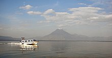
 On our boat, starting back toward bus.


 Corn field at top of old volcano crater.


 Vendor jumped onto boat to keep selling!


 Blue Heron.


 Second boat with second bus of cruise passengers.
 Funeral procession on way to church.


 Red cherries on coffee bushes.

 Quilt on display at vendor booth at our pier.
Our next port call is Cabo San Lucas, Baja California after three sea days.


Comments
Post a Comment