Wednesday, November 27, 2019, Cape Horn
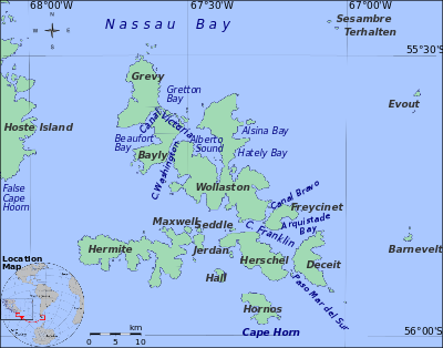
The islands around Cape Horn between South America and Antarctica.
Cape Horn
Rising like a pillar above
the point where the Atlantic and Pacific Oceans converge, Cape Horn, named for
the Dutch city of Hoorn in The Netherlands, home of the land’s discoverers, is
part of the Hermite Islands archipelago.
This remote, stark, and treeless place is often considered the continent’s
southernmost point, though the lesser known Diego Ramirez Islands are farther
south. The highest point of the Cape
soars from Hornos Island, a massive prehistoric looking massif of Jurassic
volcanic rock. The historic lighthouse
is near the water’s edge. A beacon of
assurance and safety for countless sailors since 1991, it is the world’s
southernmost traditional style lighthouse.

As we approached the Cape from the east, we saw this rainbow even though the sun was not out due to fog and clouds.

Cape Horn (Spanish: Cabo de Hornos, pronounced [ˈkaβo ðe ˈoɾnos]) is the southernmost headland of the Tierra del Fuego archipelago of southern Chile, and is located on the small Hornos Island. Although not the most southerly point of South America (which are the Diego Ramírez Islands), Cape Horn marks the northern boundary of the Drake Passage and marks where the Atlantic and Pacific Oceans meet.
Cape Horn was discovered and first rounded in 1616 by the Dutchman Willem Schouten, who named it Kaap Hoorn after the city of Hoorn in the Netherlands. For decades, Cape Horn was a major milestone on the clipper route, by which sailing ships carried trade around the world. The waters around Cape Horn are particularly hazardous, owing to strong winds, large waves, strong currents, and icebergs.
The need for boats and ships to round Cape Horn was greatly reduced by the opening of the Panama Canal in August 1914. However, sailing around the Cape Horn is still widely regarded as one of the major challenges in yachting. Thus a few recreational sailors continue to sail this route, sometimes as part of a circumnavigation of the globe. Almost all of these choose routes through the channels to the north of the Cape. (Many take a detour through the islands and anchor to wait for fair weather to visit Horn Island, or sail around it to replicate a rounding of this historic point.) Several prominent ocean yacht races, notably the Volvo Ocean Race, the VELUX 5 Oceans, and the Vendée Globe, sail around the world via the Horn. Speed records for round-the-world sailing are recognized for following this route.


The red roofed building houses the Chilean Naval station.
Naval station and lighthouse from the east.
Two lighthouses are located near or in Cape Horn. The one located in the Chilean Navy Station is the more accessible and visited, and is commonly referred to as the Cape Horn lighthouse. However, the Chilean Navy station, including the lighthouse and the memorial, are not located on Cape Horn (which is difficult to access either by land or sea), but on another land point about one mile east-northeast.
On Cape Horn proper is a smaller 13-foot fiberglass light tower, with a focal plane of 130 feet and a range of about 13 miles. This is the authentic Cape Horn lighthouse, and as such the world's southernmost traditional lighthouse. A few minor aids to navigation are located farther south, including one in the Diego Ramírez Islands and several in Antarctica.

"The" most southern point.

Rugged west side of the horn.

The "real" lighthouse of the horn.

Naval station from the southwest.

Naval station and lighthouse from the south.

On the island's top, though barely visible from ships is a simple but beautiful aluminum sculpture of an albatross, as a memorial to the sailors who have perished in the Southern Ocean. Attending the inauguration of the memorial on December 5, 1992 were a press corps and about 50 dignitaries, including a United States couple who gave a significant financial contribution to make it happen. I'll give Cape Horn and the sculpture five stars for being awesome.
The memorial has a marble plaque which reads:
I, the albatross that awaits at the end of the world...
I am the forgotten soul of the sailors lost,
rounding Cape Horn from all the seas of the world.
But die they did not in the fierce waves,
for today toward eternity, in my wings they soar,
in the last crevice of the Antarctic winds.


Personnel from a research cruise ship.


This afternoon we will return to the Ushuaia area (today's destination/goal was to circumnavigate the cape) so we can view 5-6 glaciers along the Beagle Channel as we head for Punta Arena, Chile.


Comments
Post a Comment