Friday, October 31, 2019, Amazon River


Thirty hours (400 miles) prior to our arrival at the mouth of the Amazon River, suddenly the ocean water turned muddy brown in color. The facts about the Amazon are amazing and staggering. For greater details please read the URL below.
The largest river in
the world by volume, the Amazon feeds the world’s largest and densest
rainforest, known as “the lungs of the world” for the oxygen it produces. More than 1,000 bird species and 45,000 types
of plants line the river’s shores, more than any other biosphere. The river itself harbors a staggering
diversity of life, from freshwater dolphin to piranha fish.
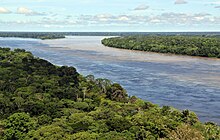
 Near the mouth, the Amazon has been called
the “river sea” for its vast width, the accumulated waters of more than 1,000
tributaries. In this breathtaking river,
one of nature’s most fascinating natural phenomena unfolds: The Meeting of the Waters, where the dark
waters of the Black River run side by side along the brown waters of the
Amazon.
Near the mouth, the Amazon has been called
the “river sea” for its vast width, the accumulated waters of more than 1,000
tributaries. In this breathtaking river,
one of nature’s most fascinating natural phenomena unfolds: The Meeting of the Waters, where the dark
waters of the Black River run side by side along the brown waters of the
Amazon.
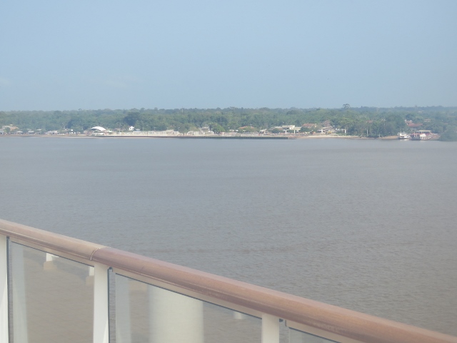
 Pictures about 75 miles up the river from the mouth we stopped to take on the pilot and immigration crew. The pilot crew will be with us the entire time until we return to this area almost a week from now. The little village of Macapa.


 The river is very wide for quite a ways in; small island along the way. Note boat in lower picture.


On our way again; almost 900 miles to our final inland destination.


The headwaters of the Apurímac River on Nevado Mismi had been considered for nearly a
century as the Amazon's most distant source, until a 2014 study found it to be
the headwaters of the Mantaro River on
the Cordillera Rumi Cruz in Peru. The
Mantaro and Apurímac join, and with other tributaries form the Ucayali River, which in turn meets the Marañón River upstream
of Iquitos, Peru,
to form what countries other than Brazil consider to be the main stem of the Amazon. Brazilians call this section the Solimões River above its confluence with
the Rio Negro to
form what Brazilians call the Amazon at the Meeting of Waters at Manaus, the largest city on the river.

At an average discharge of about 7,400,000 cubic feet/second (55,000,000 US gallons/second)—approximately 1,581 cubic miles/year, greater than the next seven largest independent rivers combined—the Amazon represents 20% of the global riverine discharge to the ocean. The Amazon basin is the largest drainage basin in the world, with an area of approximately 2,720,000 square miles. The portion of the river's drainage basin in Brazil alone is larger than any other river's basin. The Amazon enters Brazil with only one-fifth of the flow it finally discharges into the Atlantic Ocean, yet already has a greater flow at this point than the discharge of any other river.
Watershed
The Amazon basin, the largest in the world, covers
about 40% of South America. It drains
from west to east, from Iquitos in Peru, across Brazil to the Atlantic. It gathers its waters from 5 degrees north latitude to 20 degrees south latitude. Its most remote sources are found on the
inter-Andean plateau,
just a short distance from the Pacific Ocean.
The
Amazon River and its tributaries are characterized by extensive forested areas
that become flooded every rainy season. Every
year, the river rises more than 30 feet, flooding the surrounding forests,
known as várzea ("flooded
forests"). The Amazon's flooded
forests are the most extensive example of this habitat type in the world. In
an average dry season, 42,000 square miles of land are
water-covered, while in the wet season,
the flooded area of the Amazon basin rises to 140,000 square miles.
The
quantity of water released by the Amazon to the Atlantic Ocean is enormous: up
to 11,000,000 cubic feet/second in the rainy season, with an average
of 7,400,000 cubic per second from 1973 to 1990. The
Amazon is responsible for about 20% of the Earth's fresh water entering
the ocean.
The river pushes a vast plume of fresh water into the
ocean. The plume is about 250 miles
long and between 62 and 124 miles wide. The fresh water, being lighter, flows on top
of the seawater, diluting the salinity and
altering the color of the ocean surface over an area up to 970,000 square miles
in extent. For centuries ships have
reported fresh water near the Amazon's mouth yet well out of sight of land in
what otherwise seemed to be the open ocean.
The
Atlantic has sufficient wave and tidal energy to carry most of the
Amazon's sediments out
to sea, thus the Amazon does not form a true delta. The great deltas of the world are all in
relatively protected bodies of water, while the Amazon empties directly into
the turbulent Atlantic.
 There
is a natural water union between the Amazon and the Orinoco basins,
the so-called Casiquiare canal. The Casiquiare is a
river distributary of the upper Orinoco, which flows southward
into the Rio Negro, which in turn flows into the Amazon. The Casiquiare is the largest river on earth
that links two major river systems, a so-called bifurcation.
There
is a natural water union between the Amazon and the Orinoco basins,
the so-called Casiquiare canal. The Casiquiare is a
river distributary of the upper Orinoco, which flows southward
into the Rio Negro, which in turn flows into the Amazon. The Casiquiare is the largest river on earth
that links two major river systems, a so-called bifurcation.


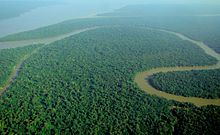
Flooding

satellite image of a flooded
portion of the river.
Not
all of the Amazon's tributaries flood at the same time of the year. Many branches begin flooding in November and
might continue to rise until June. The
rise of the Rio Negro starts in February or March and begins to recede in June.
The Madeira River rises and falls two
months earlier than most of the rest of the Amazon River.
The
depth of the Amazon between Manacapuru and Óbidos has
been calculated as between 66 to 85 feet. At Manacapuru, the Amazon's water level is
only about 79 feet above mean sea level.
More than half of the water in the
Amazon downstream of Manacapuru is below sea level. In
its lowermost section, the Amazon's depth averages 66 to 164 feet, in some
places as much as 330 feet.
The
main river is navigable for large ocean steamers to Manaus,
930 miles upriver from the mouth. Smaller
ocean vessels of 3,000 tons and 18 feet draft can
reach as far as Iquitos, Peru, 2,200 miles from the sea. Smaller riverboats
can reach 480 miles higher, as far as Achual Point. Beyond that, small boats frequently ascend to
the Pongo de Manseriche, just above Achual Point in
Peru.
Annual
flooding occurs in late northern latitude winter at high tide when the incoming
waters of the Atlantic are funneled into the Amazon
delta. The resulting undular tidal bore is
called the pororoca, with a leading wave that can be up to 25 feet high
and travel up to 500 miles inland.
https://en.wikipedia.org/wiki/Amazon_River
Today being Halloween the crew set up some appropriate tables.


Our destination tomorrow at 7 AM is Santarem where we will go on two excursions.
Today being Halloween the crew set up some appropriate tables.


Our destination tomorrow at 7 AM is Santarem where we will go on two excursions.


Comments
Post a Comment